Big Data:
- Big Datais a collection of data that is huge in volume, yet growing exponentially with time.
- It is a data with so large size and complexity that none of traditional data management tools can store it or process it efficiently.
- Big data is also a data but with huge size.
Types of Big Data:
Following are the types of Big Data:
- Structured
- Unstructured
- Semi-structured
Structured:
- Any data that can be stored, accessed and processed in the form of fixed format is termed as a ‘structured’ data.
- Over the period of time, talent in computer science has achieved greater success in developing techniques for working with such kind of data (where the format is well known in advance) and also deriving value out of it.
- However, nowadays, we are foreseeing issues when a size of such data grows to a huge extent, typical sizes are being in the rage of multiple zettabytes.
Unstructured:
- Any data with unknown form or the structure is classified as unstructured data.
- In addition to the size being huge, un-structured data poses multiple challenges in terms of its processing for deriving value out of it.
- A typical example of unstructured data is a heterogeneous data source containing a combination of simple text files, images, videos etc.
- Now day organizations have wealth of data available with them but unfortunately, they don’t know how to derive value out of it since this data is in its raw form or unstructured format.
Semi-structured:
- Semi-structured data can contain both the forms of data. We can see semi-structured data as a structured in form but it is actually not defined with e.g. a table definition in relational DBMS.
- Example of semi-structured data is a data represented in an XML file.
5 V’s of Big Data
- Volume
- Veracity
- Variety
- Value
- Velocity
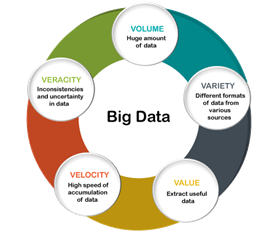
Volume:
- The name Big Data itself is related to an enormous size.
- Big Data is a vast ‘volumes’ of data generated from many sources daily, such as business processes, machines, social media platforms, networks, human interactions,and many more.
Variety:
- Big Data can be structured, unstructured, and semi-structuredthat are being collected from different sources.
- Data will only be collected from databasesand sheets in the past, But these days the data will comes in array forms, that are PDFs, Emails, audios, SM posts, photos, videos,
Veracity:
- Veracity means how much the data is reliable.
- It has many ways to filter or translate the data.
- Veracity is the process of being able to handle and manage data efficiently.
- Big Data is also essential in business development.
- For example,Facebook posts with hashtags.
Value:
- Value is an essential characteristic of big data.
- It is not the data that we process or store.
- It is valuableand reliable data that we store, process, and also analyze.
Velocity:
- Velocity plays an important role compared to others.
- Velocity creates the speed by which the data is created in real-time.
- It contains the linking of incoming data sets speeds, rate of change, and activity bursts.
- The primary aspect of Big Data is to provide demanding data rapidly.
- Big datavelocity deals with the speed at the data flows from sources like application logs, business processes, networks, and social media sites, sensors, mobile devices,
Applications of Big Data:
1) Travel and Tourism:
- Travel and tourismare the users of Big Data. It enables us to forecast travel facilities requirements at multiple locations, improve business through dynamic pricing, and many more.
2) Financial and banking sector:
- The financial andbanking sectors use big data technology extensively.
- Big dataanalytics help banks and customer behaviour on the basis of investment patterns, shopping trends, motivation to invest, and inputs that are obtained from personal or financial
3) Healthcare:
- Big data has started making a massive difference in the healthcaresector, with the help of predictive analytics, medical professionals, and health care personnel.
- It can produce personalized healthcareand solopatients also.
4) Telecommunication and media:
- Telecommunications and the multimediasector are the main users of Big Data.
- There are zettabytesto be generated every day and handling large-scale data that require big data technologies.
5) Government and Military:
- The government and militaryalso used technology at high rates.
- We see the figures that the governmentmakes on the record. In the military, a fighter plane requires to process petabytes of data.
- Government agencies use Big Data and run many agencies, managing utilities, dealing with traffic jams, and the effect of crime like hackingand online fraud.
- Aadhar Card:The government has a record of 21 billion citizens.
- This vast data is analyzed and store to find things like the number of youth in the country.
- Some schemes are built to target the maximum population.
- Big data cannot store in a traditional database, so it stores and analyze data by using the Big Data Analytics tools.
6) E-commerce:
- E-commerce is also an application of Big data.
- It maintains relationships with customers that is essential for the e-commerce industry.
- E-commerce websites have many marketing ideas to retail merchandise customers, manage transactions, and implement better strategies of innovative ideas to improve businesses with Big data.
- Amazon:
- Amazon is a tremendous e-commerce website dealing with lots of traffic daily.
- But, when there is a pre-announced sale on Amazon, traffic increase rapidly that may crash the website.
- So, to handle this type of traffic and data, it uses Big Data.
- Big Data help in organizing and analyzing the data for far use.
7) Social Media:
- Social Media is the largest data generator.
- The statistics have shown that around 500+terabytes of fresh data generated from social media daily, particularly on Facebook.
- The data mainly contains videos, photos, message exchanges,
- A single activity on the social media site generates many stored data and gets processed when required.
- The data stored is in terabytes (TB); it takes a lot of time for processing.
Advantages of Big Data:
- Big data analysis derives innovative solutions. Big data analysis helps in understanding and targeting customers. It helps in optimizing business processes.
- It helps in improving science and research.
- It improves healthcare and public health with availability of record of patients.
- It helps in financial tradings, sports, polling, security/law enforcement etc.
- Any one can access vast information via surveys and deliver anaswer of any query.
- Every second additions are made.
- One platform carry unlimited information.
Disadvantages of Big Data:
- Traditional storage can cost lot of money to store big data.
- Lots of big data is unstructured.
- Big data analysis violates principles of privacy.
- It can be used for manipulation of customer records.
- It may increase social stratification.
- Big data analysis is not useful in short run. It needs to be analyzed for longer duration to leverage its benefits.
- Big data analysis results are misleading sometimes.
- Speedy updates in big data can mismatch real figures.
Blockchain Technology:
- Blockchaincan be defined as a chain of blocks that contains information.
- The technique is intended to timestamp digital documents so that it’s not possible to backdate them or temper them.
- The purpose of blockchain is to solve the double records problem without the need for a central server.
Characteristics and Components:
- Ledger:Any file with a constantly growing record related to the transaction.
- Permanent:transaction means that once the transaction goes inside a Blockchain, it is stored permanently in the record and immutable.
- Secure:Information is stored securely through this technology as highly advanced cryptographic techniques are used to ensure that your information is locked within the Blockchain.
- Chronological:It means every transaction occurs after the previous one.
Architecture:
- A Blockchain is a chain of blocks that contain information.
- The data which is stored inside a block depends on the type of blockchain.
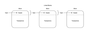
Blocks:
- Blocks are data sets and contain valuable information as a block header that helps in its verification in a neighborhood.
- The information contained in the block header can be defined as:
- the current version of the block
- previous block header hash as a reference to the parent block
- an encrypted hash of all transactions taking place in this block known as Merkle root hash
- time of the block creation
- nBits
- nonce – any random number that is assigned by a block creator that can be changed as and when required
- The remaining part in a block consists of transactions set by the data miner to include in the block.
- In terms of the blockchain architecture, there are different types of blocks based on their functionalities:
- Main branch blocks –The ones that extend the main blockchain network in current use.
- Side branch blocks –These refer to parent blocks that aren’t present in the current blockchain.
- Orphan blocks –These refer to parent blocks unknown to the node analyzing the current blockchain.
Transactions:
- Transactions, on the other hand, are what drive any blockchain network, containing the address of the recipient, sender, and respective values.
- It is the transactions that are collated and sent across nodes in blocks, which then get processed by each node individually.
- It is this continuous movement of data that builds up the blockchain architecture.
- Each transaction can have single/multiple inputs and outputs.
- Here input means the reference value from a previous transaction, and output means the amount and address.
Mining:
- Mining is what drives the blockchain architectureinto working seamlessly.
- Their work is similar to that of the credit card processing network.
- Here, each of the transactions waiting in the queue gets verified by the cross-checking of their values.
- Once the transaction is deemed accurate, the transaction is packaged into relevant blocks and entered into the network.
Consensus:
- It is the term that symbolizes the agreement of maximum nodes on the network having the same blocks in a validated blockchain.
- It can be interpreted as a series of rules that each block self-enforces, in harmony.
- With an increase in the network, the miners and nodes create an overall consensus updating with newer nodes.
Applications of Blockchain Technology:
- It is used to create a secure and transparent digital ledger of all transactions.
- It allows you to create a tamper-proof record of academic achievement that is accessible to all students and teachers.
- It is used for creating a more efficient system for trading securities.
- Lenders use blockchain to execute collateralized loans through smart contracts
- Using blockchain technology to record real estate transactions can provide a more secure and accessible means of verifying and transferring ownership.
- Use for keeping data like Social Security number, date of birth, and other identifying information on a public ledger.
- Blockchain technology is also used in the logistics industry as it helps to track items as they move through a logistics or supply chain network.
Limitations of Blockchain technology:
- Higher costs: Nodes seek higher rewards for completing Transactions in a business that work on the principle of Supply and Demand
- Slower transactions: Nodes prioritize transactions with higher rewards, backlogs of transactions build-up
- smaller ledger: It is not possible to a full copy of the Blockchain, potentially which can affect immutability, consensus, etc.
- Transaction costs, network speed: The transactions cost of Bitcoin is quite high after being touted as ‘nearly free’ for the first few years.
- Risk of error:
- There is always a risk of error, as long as the human factor is involved.
- In case a blockchain serves as a database, all the incoming data has to be of high quality.
- However, human involvement can quickly resolve the error.
- Wasteful:
- Every node that runs the blockchain has to maintain consensus across the blockchain.
- This offers very low downtime and makes data stored on the blockchain forever unchangeable.
- However, all this is wasteful because each node repeats a task to reach a consensus.
Cryptocurrency:
- A cryptocurrency is an encrypted data string that denotes a unit of currency.
- It is monitored and organized by a peer-to-peer network called a blockchain, which also serves as a secure ledger of transactions, e.g., buying, selling, and transferring.
- Unlike physical money, cryptocurrencies are decentralized, which means they are not issued by governments or other financial institutions.
- Cryptocurrencies are digital or virtual currencies underpinned by cryptographic systems.
- They enable secure online payments without the use of third-party intermediaries.
- “Crypto” refers to the various encryption algorithms and cryptographic techniques that safeguard these entries, such as elliptical curve encryption, public-private key pairs, and hashing functions.
Types of Cryptocurrency:
1) Bitcoin:
- Bitcoin is the oldest and most popular cryptocurrency in the world.
- It was created in 2009.
- It is the first decentralised cryptocurrency that facilitated transactions using its own blockchain technology.
- At the time of writing, Bitcoin was priced at roughly ₹ 37.34 lakhs.
2) Ethereum:
- Ethereum is a cryptocurrency network that uses blockchain technology to facilitate smart contracts.
- It is a decentralised software that allows smart contracts to be built on its network and run on it without any control or fear of fraud by a third party.
- Ether is the token used to enable transactions on the Ethereum network.
- Ethereum is currently priced at roughly ₹ 2.46 lakhs.
3) Dogecoin:
- This cryptocurrency was created using a popular meme that features a Shiba Inu dog as its icon.
- The meme was immensely popular as is the cryptocurrency whose price skyrocketed after receiving backing from Tesla CEO Elon Musk.
- Musk managed to shake up the already volatile crypto market by backing the meme coin.
- Dogecoin, unlike Bitcoin, has no limit on the number of coins that can be mined. It’s is currently priced at ₹ 22.49.
4) Cardano:
- Cardano was created through a research-based approach by a team of mathematicians, engineers, and cryptographers.
- In the ecosystem of cryptocurrencies, Cardano claims to be a more sustainable and balanced coin when compared to the other cryptocurrencies.
- It is currently priced at ₹ 210.78.
5) Litecoin (LTC):
- It was created in 2011 by Charlie Lee, a graduate from MIT and an engineer at Google.
- It was one of the first few cryptocurrencies that followed the same technology as Bitcoin.
- Despite being modeled on Bitcoin, Litecoin generates blocks at a faster rate, and, hence, offers a faster transaction time.
- It is currently priced at ₹ 13,631.
Advantages:
- A cryptocurrency transaction is generally a quick and straightforward process. For example, Bitcoins can be transferred from one digital wallet to another, using only a smartphone or computer.
- Every cryptocurrency transaction is recorded in a public list called the blockchain, which is the technology that enables its existence. This makes it possible to trace the history of Bitcoins to stop people from spending coins they do not own, making copies or undoing transactions.
- Blockchain aims to cut out intermediaries, such as banks and online marketplaces, which means there are no payment processing fees.
- Cyptocurrency payments are becoming more widely used, amongst large organisations, and in sectors including fashion and pharmaceuticals.
Disadvantages:
- It is possible to lose your virtual wallet or delete your currency. There have also been thefts from websites that let you store your cryptocurrency remotely.
- The value of cryptocurrencies such as Bitcoins can change significantly, so some people don’t feel it is safe to turn ‘real’ money into Bitcoins.
- The cryptocurrency market is not regulated by the Financial Conduct Authority (FCA) so there are no rules in place to protect your business.
- If companies or consumers move to a new cryptocurrency from you or stop using digital currencies entirely, it could lose value and become worthless.
- Cryptocurrency exchanges are vulnerable to cyber attacks, which could lead to an irreparable loss of your investment.
- Cryptocurrency can be vulnerable to scams.
- Scammers often use platforms like Facebook, Instagram and Twitter to trick people into these investments.
- If you suspect you’ve been targeted, it’s important to report this to Action Fraud as soon as possible.
Cloud storage:
- It is the delivery of computing services—including servers, storage, databases, networking, software, analytics, and intelligence—over the Internet (“the cloud”) to offer faster innovation, flexible resources, and economies of scale.
- The Government of India is embracing cloud computing technology for expanding its e-governance initiatives throughout the country.
- In order to utilise and harness the benefits of Cloud Computing, Government of India has embarked upon an ambitious initiative – “GI Cloud” which has been named as ‘MeghRaj’.
- The focus of this initiative is to accelerate delivery of e-services in the country while optimizing ICT spending of the Government.
Advantages:
- Seamless Connectivity:
- Cloud-based software offers companies from all sectors a number of benefits, including the ability to use software from any device either via a native app or a browser.
- As a result, users can carry their files and settings over to other devices in a completely seamless manner.
- Higher Accessibility:
- Cloud computing is far more than just accessing files on multiple devices.
- Thanks to cloud computing services, users can check their email on any computer and even store files using services such as Dropbox and Google Drive.
- Improved Disaster Recovery: Cloud computing services also make it possible for users to back up their music, files, and photos, ensuring those files are immediately available in the event of a hard drive crash.
- Cost-Saving: It also offers big businesses huge cost-saving potential. Before the cloud became a viable alternative, companies were required to purchase, construct, and maintain costly information management technology and infrastructure.
- Scalability:can be improvised to cater to increased demand, say in SMART city mission
- Companies can swap costly server centers and IT departments for fast Internet connections, where employees interact with the cloud online to complete their tasks.
- The cloud structure allows individuals to save storage space on their desktops or laptops.
- Increased Collaboration and flexibility: It also lets users upgrade software more quickly because software companies can offer their products via the web rather than through more traditional, tangible methods involving discs or flash drives.
- For example, Adobe customers can access applications in its Creative Suite through an Internet-based subscription. This allows users to download new versions and fixes to their programs easily.
- Environmentally friendly: Cloud computing reduces a company’s carbon footprint by minimizing energy consumption and carbon emissions by more than 30%. For small businesses, the decreased energy usage can reach up to 90% = A huge money saver.
Cloud computing in Indian Governance:
- E-Gram Panchayat:
- The majority of the Indian population lives in villages, and the Panchayats represent the face of governance for these villagers.
- To improve the quality of governance, the Indian government initiated an e-governance scheme known as ePanchayat to simplify and enhance internal government operations.
- The module was constructed in 4 phases of e-governance.
- Indian Railways on Cloud:
- Governed by the Central Railway Ministry of India, the Indian railway network is the largest rail network in Asia and second-largest rail network in the world.
- A research carried by the railway ministry says out of 17 million passengers every day, only 1 million passengers carry confirmed rail tickets.
- This results in substantial monetary loss.
- To avoid loss, the Indian government decided to implement cloud technology for Indian railways.
- Today, the central government maintains the railway data on the cloud.
- Kisan Suvidha:
- The Indian government came up with the portal Kisan Suvidha to help farmers with the relevant information instantly.
- It delivers farmers with detailed knowledge on weather, market prices, seeds, fertilizers, pesticides, agriculture machinery, dealers, agro advisories, plant protection and IPM practices.
- It notifies them with extreme weather conditions and the changing market price.
- DigiLocker:
- DigiLocker is the public cloud-based storage introduced by the Indian government for the citizens of India.
- It is much more than an online drive where you upload your documents to be accessed depending on your convenience.
- The documents are digitally verified and signed by the government of India in a few seconds with an authentic DigiLocker verification seal.
- With more than 57.13 million users and 4.27 billion issued documents, DigiLocker has proved to be one of the biggest success stories of cloud in the government.
- eHospital:
- eHospital is the cloud-based healthcare projected implemented by the government of India to ease the process of healthcare management.
- The system was designed to speed up services like online registration, payment of fees and appointment, online diagnostic reports, checking on the availability of blood online, etc.
- This hospital model assigns a unique identification number to every patient at the time of registration.
- The medical history of a particular patient can be accessed using the number.
- In India, cloud computing has ensured the success of national initiatives and schemes such as Swachh Bharat Mission, e-Hospital, National Scholarship, My-Gov and e-Transport.
- One of India’s most landmark initiatives, the Government e-Marketplace (GeM)uses a multi-cloud architecture to ensure scalability.
- Today, the GeM serves over 50,000 buyer organisations and has a listing of over 19 lakh products and more than 80,000 services.
- NIC’s SaaS-based service, S3WaaS,has empowered district administrators to create, configure and deploy scalable and accessible websites without much effort and technical knowledge.
- The National Highway Authority of India (NHAI),announced last year that it had gone fully digital with the launch of a unique cloud-based and AI-powered big analytics platform.
- All project documents and correspondences related to NHAI will be stored in a cloud-based data lake, which is linked with GIS tagging and a unique project ID, so that project data can be retrieved easily from any location.
- The Indian Railways has given the responsibility of deploying open source Hospital Management Information System (HMIS), an integrated clinical information system, for its 125 health facilities and 650 polyclinics across the country for improved hospital administration and patient healthcare, using a cloud platform.
Super Computer:
Introduction:
- A supercomputeris the fastest computer in the world that can process a significant amount of data very quickly.
- The computing Performance of a “supercomputer” is measured very high as compared to a general purpose computer.
- The computing Performance of a supercomputeris measured in FLOPS (that is floating-point operations per second) instead of MIPS.
- The supercomputerconsists of tens of thousands of processors which can perform billions and trillions of calculations per second, or you can say that supercomputers can deliver up to nearly a hundred quadrillions of FLOPS.
- Supercomputerswere introduced in the 1960s and developed by Seymour Cray with the Atlas at the University of Manchester.
- The Cray designed CDC 1604 which was the first supercomputer in the world, and it replaces vacuum tube with transistors.
Characteristics of Supercomputer:
- They can support more than a hundred users at a time.
- These machines are capable of handling the massive amount of calculations that are beyond the human capabilities, i.e., the human is unable to solve such extensive calculations.
- Many individuals can access supercomputers at the same time.
- These are the most expensive computers that can ever be made.
Features of Supercomputer:
- They have more than 1 CPU (Central Processing Unit) which contains instructions so that it can interpret instructions and execute arithmetic and logical operations.
- The supercomputer can support extremely high computation speed of CPUs.
- They can operate on pairs of lists of numbers instead of pairs of numbers.
- They were used initially in applications related to national security, nuclear weapon design, and cryptography. But nowadays they are also employed by the aerospace, automotive and petroleum industries.
Applications of supercomputers:
- Scientific research:In this field, scientists use a supercomputer to analyse solar systems, satellites and other nuclear research areas.
- Data mining: Large corporations often use specialised computers to extract useful information from data storage warehouses or a cloud system. For instance, life insurance companies use supercomputers to reduce their actuarial risks.
- Weather forecasting:
- The forecasting power of supercomputers helps a climatologist predict the likelihood of rain or snowfall in the neighbourhood.
- It can also predict the actual path of hurricanes and cyclones and their probability of striking.
- Intelligence agencies:
- Government intelligence agencies use supercomputers to monitor communication between private citizens and fraudsters.
- These agencies primarily need the numerical processing power of supercomputers to encrypt cell phones, emails and satellite transmission.
- Military and defence:Supercomputing provides military and defence departments with the ability to perform virtual testing of nuclear explosions and weapon ballistics.
- Automobile:Using supercomputers, an automobile company can help people buy vehicles because before purchasing a vehicle, customers can test the simulation environment created by supercomputers.
- Smog control system:Many scientists and climatologists use supercomputers in the laboratory for predicting fog and other pollution and smog levels in a particular region.
- Entertainment industry:The movie industry uses supercomputers to create animations. Also, online gaming companies widely use supercomputers to develop animation games.
Advantages of Supercomputer:
- Cost Effective:
- Companies that use supercomputers saves a lot of time in managing tasks.
- This not only results in efficiency, it eventually lowers cost in the long run.
- And also, by using a supercomputer there is no need for the organizations to purchase expensive physical models.
- Security:
- A supercomputer offers enhanced protection by decrypting the password.
- Even passwords used in other devices will be decrypted by a supercomputer.
- Besides decrypting, a supercomputer can easily guess passwords.
- Speed:
- The time a computer takes to process tasks is significantly lesser in a supercomputer.
- They usually take very less amount of time solving calculations.
- Compared to a normal computer, this rate is almost 100-1000x lesser.
- Meaning, a task that takes several hours to complete, can be finished by a supercomputer in a fraction of seconds.
- Complex Tasks:
- Complex tasks such as rendering animations can be easily done with the help of a supercomputer.
- Along with faster rendering, it overall produces a good result.
- Environment friendly:
- A supercomputer is environment friendly to some extent by providing a virtualized testing environment for scientific and medical researches.
- Real-time testing such as nuclear weapon testing is known to cause many hazards to the environment.
Disadvantages of Supercomputer:
- Physical Size:
- Supercomputers are also physically large in size.
- Hence, they require lots of space.
- A supercomputer typically takes more than 1000 square feet of area.
- Maintenance:
- An expert staff needs to be appointed for monitoring and administrating a supercomputer.
- For this purpose, a special software is used which is capable of detecting failures and computer’s overall usage.
- Storage:
- In order for acquiring the full capacity of a supercomputer, it should be equipped with enough storage space.
- Whatever the data that is being produced will be accommodated by the storage drive.
- Therefore, it must be massive enough to store all the data.
- Without sufficient storage space, the supercomputer simply cannot perform calculations.
- Heat Release:
- A supercomputer is equipped with large number of processor all which can generate significant amount of heat during their operations.
- Due to this heat, most devices tends to get damaged easily.
- Hence for preventing this, a proper cooling system needs to be installed.
- Additionally, it is recommended to get the room air conditioned.
- Power Consumption:
- Supercomputers typically consume large amount of electricity.
- On average, a supercomputer requires about 4 megawatts (MW) of electricity.
- This amount is almost 5000x greater compared to a normal house.
- All this can lead to an increase in the expense of electricity.
Roboties:
- Robotics is an integrated study of mechanical engineering, electronic engineering, computer engineering, and science.
- Robot is a mechanical device designed with electronic circuitry and programmed to perform a special task.
- These automated machines are highly signicant in this robotic era.
- They can take up the role of humans in certain dangerous environments that are hazardous to people like defusing bombs, finding survivors in unstable ruins, and exploring mines and shipwrecks.
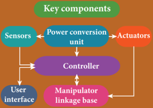
Components of robotics
The robotic system mainly consists of sensors, power supplies, control systems, manipulators and necessary software.
Most robots are composed of 3 main parts:
- The Controller ‐ also known as the “brain” which is run by a computer program. It gives commands for the moving parts to perform the job.
- Mechanical parts – motors, pistons, grippers, wheels, and gears that make the robot move, grab, turn, and lift.
- Sensors – to tell the robot about its surroundings. It helps to determine the sizes and shapes of the objects around, distance between the objects, and directions as well.
Types of Robots:
Human robot:
Certain robots are made to resemble humans in appearance and replicate the human activities like walking, lifting, and sensing, etc.
- Power conversion unit: Robots are powered by batteries, solar power, and hydraulics.
- Actuators: Converts energy into movement. e majority of the actuators produce rotational or linear motion.
- Electric motors:
- They are used to actuate the parts of the robots like wheels, arms, fingers, legs, sensors, camera, weapon systems etc.
- Different types of electric motors are used.
- The most often used ones are AC motor, Brushed DC motor, Brushless DC motor, Geared DC motor, etc.
- Pneumatic Air Muscles:
- They are devices that can contract and expand when air is pumped inside.
- It can replicate the function of a human muscle.
- They contract almost 40% when the air is sucked inside them.
- Muscle wires:
- They are thin strands of wire made of shape memory alloys.
- They can contract by 5% when electric current is passed through them.
- Piezo Motors and Ultrasonic Motors: Basically, we use it for industrial robots.
- Sensors: Generally used in task environments as it provides information of real-time knowledge.
- Robot locomotion:
- Provides the types of movements to a robot.
- The different types are
- Legged
- Wheeled
- Combination of Legged and Wheeled Locomotion
- Tracked slip/skid
Advantages of Robotics:
- The robots are much cheaper than humans.
- Robots never get tired like humans.
- It can work for 24 x 7. Hence absenteeism in work place can be reduced.
- Robots are more precise and error free in performing the task.
- Stronger and faster than humans.
- Robots can work in extreme environmental conditions: extreme hot or cold, space or underwater. In dangerous situations like bomb detection and bomb deactivation.
- In warfare, robots can save human lives.
- Robots are significantly used in handling materials in chemical industries especially in nuclear plants which can lead to health hazards in humans.
Disadvantages of Robotics:
- Robots have no sense of emotions or conscience.
- They lack empathy and hence create an emotionless workplace.
- If ultimately robots would do all the work, and the humans will just sit and monitor them, health hazards will increase rapidly.
- Unemployment problem will increase.
- Robots can perform defined tasks and cannot handle unexpected situations
- The robots are well programmed to do a job and if a small thing goes wrong it ends up in a big loss to the company.
- If a robot malfunctions, it takes time to identify the problem, rectify it, and even reprogram if necessary. This process requires significant time.
- Humans cannot be replaced by robots in decision making.
- Till the robot reaches the level of human intelligence, the humans in work place will exit.
Nano Technology:
Nanoscience:
- Nanoscience is the study of structures and materials on the scale of nanometers.
- Nano means one-billionth of a meter that is 10-9 m.
- If matter is divided into such small objects the mechanical, electrical, optical, magnetic and other properties change.
Nanotechnology:
- Nanotechnology is a technology involving the design, production, characterization, and applications of nano structured materials.
Nanoparticles:
- The solids are made up of particles.
- Each of the particle has a definite number of atoms, which might differ from material to material.
- If the particle of a solid is of size less than 100 nm, it is said to be a ‘nano solid.
- When the particle size exceeds 100 nm, it is a ‘bulk solid.
- It is to be noted that nano and bulk solids may be of the same chemical composition.
- For example, ZnO can be both in bulk and nano form. Though chemical composition is the same, nano form of the material shows strikingly different properties when compared to its bulk counterpart.
- In the nano scale dimensions (reduced dimensions), two important phenomena govern nano properties.
- They are quantum confinement effects and surface effects.
- Students can explore these effects in higher education and the explanation is avoided at school level.
Nano in Nature:
- Nanoscale structures existed in nature long before scientists began studying them in laboratories.
Example:
Single strand of DNA:
- A single strand of DNA, the building block of all living things, is about three nanometers wide.
Morpho butterfly:
- The scales on the wings of a morpho butterfly contain nanostructures that change the way light waves interact with each other, giving the wings brilliant metallic blue and green hues.
- Manipulation of colours by adjusting the size of nano particles with which the materials are made.
Peacock feathers:
- Peacock feathers get their iridescent coloration from light interacting with 2 dimensional photonic crystal structures just tens of nanometers thick.
- Similar nano structures are made in lab to glow in different colors.
Parrot fish:
- Parrot fish crunches up coral all day.
- The source of the parrotfish’s powerful bite is the interwoven fibre nanostructure.
- Crystals of a mineral called fluorapatite are woven together in a chain mail-like arrangement.
- This structure gives parrotfish teeth incredible durability.
- The natural structure provides a blueprint for creating ultra-durable synthetic materials that could be useful for mechanical components in electronics, and in other devices that undergo repetitive movement, abrasion, and contact stress.
Lotus leaf surface:
- Lotus leaf surface scanning electron micrograph (SEM) showing the nano structures on the surface of a leaf from a lotus plant.
- This is the reason for self cleaning process in lotus leaf.
- Water repellant Nano paints are made.
- Coating with such nano paints give durability, protection against stains and dirt also enhances fuel efficiency when coated on ships.
Applications of Nano technology:
Automotive industry:
- Lightweight construction
- Painting (fillers, base coat, clear coat)
- Catalysts
- Tires (fillers)
- Sensors
- Coatings for wind screen and car bodies
Electronic industry:
- Data memory
- Displays
- Laser diodes
- Glass fibres
- Optical switches
- Filters (IR-blocking)
- Conductive, antistatic coatings
Chemical industry:
- Fillers for paint systems
- Coating systems based on nanocomposites
- Impregnation of papers
- Switchable adhesives
- Magnetic fluids
Construction:
- Construction materials
- Thermal insulation
- Flame retardants
- Surface-functionalised building materials for wood, floors, stone, facades, tiles, roof tiles, etc.
- Facade coatings
- Groove mortar
Engineering:
- Wear protection for tools and machines (anti blocking coatings, scratch resistant coatings on plastic parts, etc.)
- Lubricant-free bearings
Medicine:
- Drug delivery systems
- Active agents
- Contrast medium
- Medical rapid tests
- Prostheses and implants
- Antimicrobial agents and coatings
- Agents in cancer therapy
Textile/fabrics/ non-wovens:
- Surface-processed textiles
- Smart clothes
Food and drinks:
- Package materials
- Storage life sensors
- Additives
- Clarification of fruit juices
Energy:
- Fuel cells
- Solar cells
- Batteries
- Capacitors
Household:
- Ceramic coatings for irons
- Odors catalyst
- Cleaner for glass, ceramic, floor, windows
Cosmetics:
- Sun protection
- Lipsticks
- Skin creams
- Tooth paste
Sports/ outdoor:
- Ski wax
- Antifogging of glasses/goggles
- Antifouling coatings for ships/boats
- Reinforced tennis rackets and balls
Possible harmful effects of nanoparticles:
- The research on the harmful impact of application of nanotechnology is also equally important and fast developing.
- The major concern here is that the nanoparticles have the dimensions same as that of the biological molecules such as proteins.
- They may easily get absorbed onto the surface of living organisms and they might enter the tissues and fluids of the body.
- The adsorbing nature depends on the surface of the nanoparticle.
- Indeed, it is possible to deliver a drug directly to a specific cell in the body by designing the surface of a nanoparticle so that it adsorbs specifically onto the surface of the target cell.
- The interaction with living systems is also affected by the dimensions of the nanoparticles.
- For instance, nanoparticles of a few nanometers size may reach well inside biomolecules, which is not possible for larger nanoparticles.
- Nanoparticles can also cross cell membranes.
- It is also possible for the inhaled nanoparticles to reach the blood, to reach other sites such as the liver, heart or blood cells.
- Researchers are trying to understand the response of living organisms to the presence of nanoparticles of varying size, shape, chemical composition and surface characteristics.
Artificial Intelligence:
- Artificial intelligence (AI) refers to the simulation of human intelligence in machines that are programmed to think like humans and mimic their actions.
- The term may also be applied to any machine that exhibits traits associated with a human mind such as learning and problem-solving.
Application of AI:
1. AI in Astronomy
- Artificial Intelligence can be very useful to solve complex universe problems.
- AI technology can be helpful for understanding the universe such as how it works, origin, etc.
2. AI in Healthcare
- In the last, five to ten years, AI becoming more advantageous for the healthcare industry and going to have a significant impact on this industry.
- Healthcare Industries are applying AI to make a better and faster diagnosis than humans.
- AI can help doctors with diagnoses and can inform when patients are worsening so that medical help can reach to the patient before hospitalization.
3. AI in Gaming
- AI can be used for gaming purpose.
- The AI machines can play strategic games like chess, where the machine needs to think of a large number of possible places.
4. AI in Finance
- AI and finance industries are the best matches for each other.
- The finance industry is implementing automation, chatbot, adaptive intelligence, algorithm trading, and machine learning into financial processes.
5. AI in Data Security
- The security of data is crucial for every company and cyber-attacks are growing very rapidly in the digital world.
- AI can be used to make your data more safe and secure. Some examples such as AEG bot, AI2 Platform, are used to determine software bug and cyber-attacks in a better way.
6. AI in Social Media
- Social Media sites such as Facebook, Twitter, and Snapchat contain billions of user profiles, which need to be stored and managed in a very efficient way.
- AI can organize and manage massive amounts of data.
- AI can analyze lots of data to identify the latest trends, hashtag, and requirement of different users.
7. AI in Travel & Transport
- AI is becoming highly demanding for travel industries.
- AI is capable of doing various travel related works such as from making travel arrangement to suggesting the hotels, flights, and best routes to the customers.
- Travel industries are using AI-powered chatbots which can make human-like interaction with customers for better and fast response.
8. AI in Automotive Industry
- Some Automotive industries are using AI to provide virtual assistant to their user for better performance.
- Such as Tesla has introduced Tesla Bot, an intelligent virtual assistant.
- Various Industries are currently working for developing self-driven cars which can make your journey more safe and secure.
9. AI in Robotics:
- Artificial Intelligence has a remarkable role in Robotics.
- Usually, general robots are programmed such that they can perform some repetitive task, but with the help of AI, we can create intelligent robots which can perform tasks with their own experiences without pre-programmed.
- Humanoid Robots are best examples for AI in robotics, recently the intelligent Humanoid robot named as Erica and Sophia has been developed which can talk and behave like humans.
10. AI in Entertainment
- We are currently using some AI based applications in our daily life with some entertainment services such as Netflix or Amazon.
- With the help of ML/AI algorithms, these services show the recommendations for programs or shows.
11. AI in Agriculture
- Agriculture is an area which requires various resources, labor, money, and time for best result.
- Now a day’s agriculture is becoming digital, and AI is emerging in this field.
- Agriculture is applying AI as agriculture robotics, solid and crop monitoring, predictive analysis.
- AI in agriculture can be very helpful for farmers.
12. AI in E-commerce
- AI is providing a competitive edge to the e-commerce industry, and it is becoming more demanding in the e-commerce business.
- AI is helping shoppers to discover associated products with recommended size, color, or even brand.
13. AI in education:
- AI can automate grading so that the tutor can have more time to teach. AI chatbot can communicate with students as a teaching assistant.
- AI in the future can be work as a personal virtual tutor for students, which will be accessible easily at any time and any place.
Advantages of Artificial Intelligence:
- High Accuracy with less errors:AI machines or systems are prone to less errors and high accuracy as it takes decisions as per pre-experience or information.
- High-Speed:AI systems can be of very high-speed and fast-decision making, because of that AI systems can beat a chess champion in the Chess game.
- High reliability:AI machines are highly reliable and can perform the same action multiple times with high accuracy.
- Useful for risky areas:AI machines can be helpful in situations such as defusing a bomb, exploring the ocean floor, where to employ a human can be risky.
- Digital Assistant:AI can be very useful to provide digital assistant to the users such as AI technology is currently used by various E-commerce websites to show the products as per customer requirement.
- Useful as a public utility:AI can be very useful for public utilities such as a self-driving car which can make our journey safer and hassle-free, facial recognition for security purpose, Natural language processing to communicate with the human in human-language, etc.
Disadvantages of Artificial Intelligence:
- High Cost:The hardware and software requirement of AI is very costly as it requires lots of maintenance to meet current world requirements.
- Can’t think out of the box:Even we are making smarter machines with AI, but still they cannot work out of the box, as the robot will only do that work for which they are trained, or programmed.
- No feelings and emotions:AI machines can be an outstanding performer, but still it does not have the feeling so it cannot make any kind of emotional attachment with human, and may sometime be harmful for users if the proper care is not taken.
- Increase dependency on machines:With the increment of technology, people are getting more dependent on devices and hence they are losing their mental capabilities.
- No Original Creativity:As humans are so creative and can imagine some new ideas but still AI machines cannot beat this power of human intelligence and cannot be creative and imaginative.
Policies of Artificial Intelligence:
- Basic and Applied Research:
- To achieve new breakthroughs in AI theories, technologies, and applications, governments need to provide funding for basic and applied research.
- This includes both research grants and the creation of new research institutions. Example: the UK’s Alan Turing Institute.
- Talent Attraction, Development, and Retainment:To conduct R&D in AI and deploy AI solutions in the public and private sectors, countries need a supply of skilled AI talent. Example: Canada’s CIFAR Chairs in AI Program.
- Future of Work and Skills:Advances in AI will both create and destroy jobs. To ensure that workers have the skills to compete in the digital economy, governments need to invest in STEM education, national retraining programs, and lifelong learning. Example: Denmark’s Technology Pact.
- Industrialization of AI Technologies:
- AI has the potential to fundamentally transform multiple sectors and drive growth for decades to come.
- To encourage private sector uptake, governments are investing in strategic sectors and developing AI ecosystems and clusters. Example: Japan’s Industrialization Roadmap.
- AI in the Government:
- Likewise, governments are experimenting with ways to encourage the uptake of AI in the government.
- With the help of AI, it is possible to reform the public administration and make policy more effective. Example: UAE’s Ministry of Artificial Intelligence.
- Data and Digital Infrastructure:
- Data is central to the ability of AI to work.
- As a result, governments are opening their datasets and developing platforms to encourage the secure exchange of private data. Example: France’s Health Data Hub.
- Ethics:
- Concerns over algorithmic bias, privacy, and security have raised a number of ethical debates.
- To mitigate harm, governments are looking to develop ethical codes and standards for the use and development of AI. Example: The EU’s Draft AI Ethics Guidelines.
- Regulations:
- Every country is grappling with the question of whether (and how) to regulate AI.
- Currently, governments are focused on regulations for autonomous cars and autonomous weapons. Example: Germany’s Ethics Commission on Automated and Connected Driving.
- Inclusion:
- AI can both improve and worsen inclusion.
- Used properly, AI can bolster inclusion and help address complex societal problems such as poverty and hunger.
- Used improperly, AI can reinforce discrimination and disproportionately harm women and minorities. Example: India’s #AIforAll Strategy.
Foreign Policy:
- Geopolitics, development, and trade will all be affected by advances in AI technologies.
- To address ethical concerns and develop global standards, countries are beginning to consider mechanisms for the global governance of AI. Example: China’s Global Governance of AI Plan
IoT (Internet of Things):
- The internet of things, or IoT, is a system of interrelated computing devices, mechanical and digital machines, objects, animals or people that are provided with unique identifiers (UIDs) and the ability to transfer data over a network without requiring human-to-human or human-to-computer interaction.
IoT technologies:
Technologies used in IoT systems may include:
- Edge computing
- Edge computing refers to the technology used to make smart devices do more than just send or receive data to their IoT platform.
- It increases the computing power at the edges of an IoT network, reducing communication latency and improving response time.
- Cloud computing
Cloud technology is used for remote data storage and IoT device management – making the data accessible to multiple devices in the network.
- Machine learning
- Machine learning refers to the software and algorithms used to process data and make real-time decisions based on that data.
- These machine learning algorithms can be deployed in the cloud or at the edge.
Architecture of IoT:
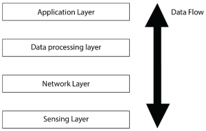
- Sensing Layer − The first stage of IoT includes sensors, devices, actuators etc. which collect data from the physical environment, processes it and then sends it over the network.
- Network Layer
- The second stage of the IoT consists of Network Gateways and Data Acquisition Systems.
- DAS converts the analogue data (collected from Sensors) into Digital Data.
- It also performs malware detection and data management.
- Data Processing Layer
- The third stage of IoT is the most important stage.
- Here, data is pre-processed on its variety and separated accordingly.
- After this, it is sent to Data Centres.
- Here Edge IT comes into use.
- Application Layer − The fourth stage of IoT consists of Cloud/Data Centres where data is managed and used by applications like agriculture, defence, health care etc.
Advantages:
- Cost Reduction
- IOT devices catch any problem very fast as compared to traditional troubleshooting.
- It not only saves time but also saves costs of large repairs.
- Efficiency and Productivity − An automated PDF conversion and creation tool will remove the hustle of PDF editing and archiving. Hence, increase in Efficiency and Productivity.
- Business Opportunities − IOT provides advanced analytics, smart utility grids which help Small Management Businesses to provide more valuable content and things to their customers.
- Customer Experience
- Nowadays customer’s experience is the most valuable thing in running a business.
- IoT has drastically increased the customer’s experience. An example of customer experience is Home Automation.
- Since everything is connected, customers need not have to worry about appliances.
- One can turn off the appliance through mobile.
- Mobility and Agility − With the help of IoT, employees can do their work from any geographical location, anytime without any restrictions.
Disadvantages:
- Security
- The data is travelling all over the Internet.
- So maintaining its privacy is still a Big Challenge.
- End-to-end Encryption is a must in IoT.
- Compatibility − There is no International Standard for the monitoring of the equipment.
- Complexity
- Most of the devices still contain some software bugs.
- Each device must be able to seamlessly interact with other devices in the network.
- Safety
- Suppose a patient is left unattended by a doctor.
- And some notorious guy changes the prescription or Health monitoring devices malfunctioned.
- Then it can result in the death of the patient.
- Policies − Government authorities must take some steps to make policies and standards related to IoT to stop the Black marketing of IoT devices.
Features of IOT:
- Connectivity:
- Connectivity refers to establish a proper connection between all the things of IoT to IoT platform it may be server or cloud.
- After connecting the IoT devices, it needs a high speed messaging between the devices and cloud to enable reliable, secure and bi-directional communication.
- Analyzing:
- After connecting all the relevant things, it comes to real-time analyzing the data collected and use them to build effective business intelligence.
- If we have a good insight into data gathered from all these things, then we call our system has a smart system.
- Integrating:IoT integrating the various models to improve the user experience as well.
- Artificial Intelligence:IoT makes things smart and enhances life through the use of data. For example, if we have a coffee machine whose beans have going to end, then the coffee machine itself order the coffee beans of your choice from the retailer.
- Sensing:
- The sensor devices used in IoT technologies detect and measure any change in the environment and report on their status.
- IoT technology brings passive networks to active networks.
- Without sensors, there could not hold an effective or true IoT environment.
- Active Engagement:IoT makes the connected technology, product, or services to active engagement between each other.
- Endpoint Management:
- It is important to be the endpoint management of all the IoT system otherwise, it makes the complete failure of the system.
- For example, if a coffee machine itself order the coffee beans when it goes to end but what happens when it orders the beans from a retailer and we are not present at home for a few days, it leads to the failure of the IoT system. So, there must be a need for endpoint management
Virtual Reality:
- Virtual reality is an artificial environment that is created with software and presented to the user in such a way that the user suspends belief and accepts it as a real environment.
- On a computer, virtual reality is primarily experienced through two of the five senses: sight and sound.
- The simplest form of virtual reality is a 3-Dimage that can be explored interactively at a personal computer, usually by manipulating keys or the mouse so that the content of the image moves in some direction or zooms in or out.
- More sophisticated efforts involve such approaches as wrap-around display screens, actual rooms augmented with wearable computers, and hapticsdevices that let you feel the display images.
Virtual reality can be divided into:
- The simulation of a real environment for training and education.
- The development of an imagined environment for a game or interactive story.
- The Virtual Reality Modelling Language (VRML) allows the creator to specify images and the rules for their display and interaction using textual language statements.
Purpose:
- The goal of VR is to provide human beings with a virtual environment where we can interact with a computer just as we do in the real world, that is, by talking with a virtual human in a spoken language, by writing a letter, or by drawing a picture.
Types of virtual reality:
- There are three main types of virtual reality used today to transform the world around us, including non-immersive, semi-immersive, and fully-immersive simulations.
Fully-immersive simulations:
- Chances are when you think of VR, you’re picturing a fully-immersive experience – complete with head-mounted displays, headphones, gloves, and maybe a treadmill or some kind of suspension apparatus.
- This type of VR is commonly used for gaming and other entertainment purposes in VR arcades or even in your home (empty, non-fragile room advised.)
- Fully-immersive simulations give users the most realistic experience possible, complete with sight and sound. The VR headsets provide high-resolution content with a wide field of view. Whether you’re flying or fighting the bad guys, you’ll feel like you’re really there.
Semi-immersive simulations:
- Semi-immersive experiences provide users with a partially virtual environment to interact with.
- This type of VR is mainly used for educationaland training purposes and the experience is made possible with graphical computing and large projector systems.
- In this example, the instruments in front of the pilot are real and the windows are screens displaying virtual content.
- It’s important to keep in mind that semi-immersive VR simulations still give users the perception of being in a different reality.
- This type of virtual reality is not always possible to experience wherever.
- Instead, physical environments are created to supplement the virtual reality.
Non-immersive simulations:
- Non-immersive simulations are often forgotten as an actual type of VR, honestly because it’s very common in our everyday lives.
- The average video game is technically considered a non-immersive virtual reality experience.
- Think about it, you’re sitting in a physical space, interacting with a virtual one.
- These types of experiences have become more advanced in recent years with video games like Wii Sports, where the system actually detects your motion and translates it on screen.
Advantages of Virtual Reality:
· Virtual reality creates a realistic world.
· It enables user to explore places.
· Through Virtual Reality user can experiment with an artificial environment.
· Virtual Reality make the education more easily and comfort.
Disadvantages of Virtual Reality:
· The equipment used in virtual reality are very expensive.
· It consists of complex technology.
· In virtual reality environment we can’t move by our own like in the real world.
Remote Sensing:
- Remote sensing is an integrated discipline encompassing some branches of arts, science and technology of collecting information about the terrestrial objects using camera and sensor system.
Elements of Remote Sensing:
- Energy Source
- The primary requirement for remote sensing is to have an energy service, which provides electromagnetic energy to the target of interest.
- The sun being a major source of energy, radiation and illumination having a sharp power allows capturing reflected light with conventional cameras and films.
- Radiation and the Atmosphere:
- The energy is required to illuminate the target.
- This energy is in the form of Electromagnetic radiation.
- Electromagnetic radiation is a dynamic form of energy that propagates as wave motion at a velocity in space.
- Interaction with the target:
- The interaction of Electromagnetic radiation with the target is important to remote sensing for two main reasons.
- First, information carried Electromagnetic radiation reflected by the earth’s surface is modified while traversing through the atmosphere.
- Second, the interaction of Electromagnetic radiation with the atmosphere can be used to obtain useful information about the atmosphere itself.
- The total energy is subjected to modification by the several physical process, scattering, absorption and refraction.
- Scattering is the re-direction of Electromagnetic radiation by particles suspended in the atmosphere or by large molecules of atmospheric gases.
- The amount of scattering depends upon the size of the particles and their abundance.
- The wave length of radiation, depth of the atmosphere through which the energy is travelling.
- Absorption is the process by which the gas molecules present in the atmosphere strongly absorb the Electromagnetic radiation through the atmosphere in certain spectral bands.
- Recording of energy by the sensor:
- After the energy has been scattered by or emitted from the target, we require a sensor (remote not in contact with the target) to collect and record the electromagnetic radiation.
- A sensor is highly sensitive to all the wave lengths yielding spatially detailed data on absolute brightness.
- On the basis of the source of electromagnetic energy, the sensor can be classified into two ways.
- They are active sensor or passive sensor.
- Active sensor generates and uses its own energy to illuminate the target and records the reflected energy.
- It operates in the microwave regions of the electromagnetic spectrum. Their wave lengths are longer than 1 mm.
- Transmission, Reception and Processing:
- The energy recorded by the sensor has to be transmitted in electronic form, to a receiving and processing station where the data processed into an image.
- The Image processing methods may be grouped into three functional categories such as Image Restoration, Image Enhancement and Information Extraction.
- Image Restoration:
- Restoration processes are designed to recognize and compensate for errors, noise and geometric distortion introduced into the data during the scanning transmission and recording processes.
- The objective is to make the image resemble the original scene.
- Image restoration is relatively simple because the pixels from each band are processed separately.
- Image Enhancement:
- Enhancement is the modification of an image, to alter its impact on viewer.
- General enhancement distorts the original digital values; therefore enhancement is not done until the restoration processes are completed.
- Information extraction:
- Image restoration and enhancement process utilize computers to provide corrected and improved images for study by human interpreters.
- The computer makes no decision in these procedures.
- The human operator must instruct the computer and must evaluate the significance of the extracted information.
- Interpretation and Analysis:
- Image interpretation is defined as the act of examining images to identify objects and judge their significance.
- An interpreter studies remotely sensed data and attempts through logical process to detect, identify, measure and evaluate the significance of environment and cultural object pattern and spatial relationship.
- The quality of an image is based on the inherent characteristics of the objects. Further it depends on the following aspects.
- Sensor characteristics
- Season of the year, time of the day when the photo is taken
- Atmospheric effects
- Resolution of the image
- Image motion etc.
- Image interpretation is essential for the efficient and effective use of the data.
- The elements of image interpretation such as image tone, shape, size, pattern, image texture, shadow and association are helpful to identify the exact target and to analyse.
Classification of remote sensing:
- On the basis of the sources of electromagnetic energy, the remote sensing can be classified as passive and active remote sensing.
- In a simple way, we can understand that the passive remote sensing is similar to taking a picture with an ordinary camera where as active remote sensing is analogous to taking picture with camera having built-in flash.
- On the basis of the energy source, the active remote sensing generates and uses its own energy to illuminate the target and records the reflected energy where as the passive remote sensing depend on solar radiation to illuminate the target.
- On the basis of region of spectrum in which they operate, the active remote sensing operate in the microwave region of the electromagnetic spectrum where as the passive remote sensing operate in the visible and infrared region of the electromagnetic spectrum.
- The wave lengths of the active remote sensing are longer than 1 mm where as the passive remote sensing, the wave length range from 0.4 to 1.0 mm.
- Some examples of active sensors are Fluorosensor and Synthetic Aperture Radar (SAR).
- Passive sensors record radiation reflected from the earth’s surface.
- The source of this radiation must come from outside the sensor; in most cases, this is solar energy.
- Because of this energy requirement, passive solar sensors can only capture data during daylight hours.
- Active sensors are different from passive sensors.
- Unlike passive sensors, active sensors require the energy source to come from within the sensor.
- A laser-beam remote sensing system is an active sensor that sends out a beam of light with a known wavelength and frequency.
- This beam of light hits the earth and is reflected back to the sensor, which records the time it took for the beam of light to return.
Remote sensing platform:
- The platform is a stage to mount the camera or sensor to acquire the information about a target under investigation.
- Based on the altitude above the earth surface, the platform can be classified as Ground borne platform, Air borne platform and Space borne platform.
Ground borne platform:
- Ground based platforms sensors may be placed on a ladder, scaffolding tall-building, crane etc.
- These are used to record detailed information about the surface which is compared with information collected from aircraft or satellite sensors.
- They are close to the ground.
- A wide variety of ground based platforms are used in remote sensing. Some of the more common ones are hand held devices, tripods, towers and cranes.
- Instruments that are ground-based are often used to measure the quantity and quality of light coming from the sun or for close range characterization of objects Permanent ground platforms are typically used for monitoring atmospheric phenomenon although they are also used for long-term monitoring of terrestrial features.
Air borne platform:
- Aircrafts are generally used to acquire aerial photographs for photo interpretation and photogrammetric purposes.
- They are classified into two types. They are
- Low altitude aerial remote sensing
- High altitude aerial remote sensing
Balloon:
- Balloons are used for remote sensing observation (aerial photography) and nature conservation studies.
- The first aerial images were acquired with a camera carried aloft by a balloon in 1859.
- Balloon floats at a constant height of about 30 km.
Drone:
- Drone is a miniature remotely piloted aircraft.
- It is designed to fulfil requirements for a low cost platform, with long endurance, moderate payload capacity and capability to operate without a runway or small runway.
- Drone includes equipment of photography, infrared detection, radar observation and TV surveillance.
- It uses satellite communication link.
- An onboard computer controls the payload and stores data from different sensors and instruments.
- The unique advantage is that it could be accurately located above the area for which data was required and capable to provide both night and day data.
Aircraft:
- The first known aerial photograph was taken in 1858 by French photographer and balloonist, Gaspar Felix Tournachon, known as “Nadar”.
- In 1855 Special aircraft with cameras and sensors on vibration less platforms are traditionally used to acquire aerial photographs and images of land surface features.
- While low altitude aerial photography results in large scale images providing detailed information on the terrain, the high altitude smaller scale images offer advantage to cover a larger study area with low spatial resolution.
Space borne platform:
- The satellites are normally used for the space borne remote sensing. The satellite moves in their orbit.
- The closed path of a satellite around the earth is called its orbit.
- These platforms are freely moving in their orbit around the earth and the entire earth or any part of the earth can be covered at specified intervals.
- The coverage mainly depends on the orbit of the satellite.
- It is through these space borne platforms, we get the enormous amount of remote sensing data.
- In space borne remote sensing, sensors are mounted on-board a spacecraft (space shuttle or satellite) orbiting the earth.
- Space borne remote sensing provides the following advantages:
- Large area coverage.
- Frequent and repetitive coverage of an area of interest.
- Quantitative measurement of ground features using radio metrically calibrated sensors.
- Semi automated computerised processing and analysis.
- Relatively lower cost per unit area of coverage.
Types of satellite:
- Satellite orbits are designed according to the capacity and objective of the sensors they carry.
- Depending on their altitude, orientation and rotation relative to the earth satellites can be categorized as
- Geostationary Satellites:
- Geostationary Satellite is an equatorial west to east satellite orbiting the earth at an altitude of 35000 km, the altitude at which it makes on revolution in 24 hours.
- These platforms are covering the same place and give continuous near hemispheric coverage over the same area day and night.
- These satellites are put in equatorial plane orbiting from west to east.
- Its coverage is limited to 70°N to 70°S latitudes and one satellite can view one-third globe.
- These are mainly used for communication and meteorological applications viz. GOES, METEOSAT, INTELSAT, and INSAT satellites.
- On June 19, 1981 India launched its first geostationary satellite called APPLE.
- It was an experimental communication satellite launched by the Indian Space Research Organisation (ISRO).
- The Ariane Passenger Payload Experiment (APPLE) was ISRO’s first indigenous, experimental communication satellite.
- Polar Orbiting or Sun-Synchronous satellite:
- As the satellite orbits the Earth from pole to pole, its east-west position would not change if the Earth did not rotate.
- However, as seen from the Earth, it seems that the satellite is shifting westward because the Earth is rotating (from west to east) beneath it.
- This apparent movement allows the satellite swath to cover a new area with each pass.
- All the remote sensing resource satellites may be grouped in this category.
- Few of these satellites are LANDSAT series, SPOT series, IRS series, NOAA SEASAT, TIROS, HCMM, SKYLAB, and SPACE SHUTTLE etc.
- Spy satellites:
- Spy satellites are observational platforms that orbit the Earth in order to image its surface and to record radio signals for military and political purposes.
- They transmit their data to Earth, where it is interpreted by specialists in centralised, secretive facilities such as the U.S. National Photographic Interpretation Centre in Washington, D.C. Spy satellites have been essential not only to military operations and the formation of national policy but to the verification of arms control treaties such as SALT I, SALT II, etc.
- The four basic types of spy satellite are:
- photo reconnaissance systems that take pictures in visible and infrared light,
- infrared telescopes designed to detect missile launches,
- radars that image sea or land even through cloud cover and in darkness, and
- signals intelligence (SIGINT) satellites (also termed “ferrets”), which are optimised either for characterising ground-based radar systems or for eavesdropping on communications.
- Sometimes photo reconnaissance and SIGINT functions are combined in single, massive platforms such as the U.S. Keyhole-series satellites.
- Although a number of nations have launched spy satellites, the U.S. and the Soviet Union are responsible for by far the greatest number.
- The Russian Federation, which inherited most of the Soviet Union’s space system after 1991, has been unable to afford the cost of adequately updating its spy satellite network.
- In contrast, the U.S. has continued to deploy ever-more-sophisticated systems in a steady stream.
- Thus, the majority of spy satellites in orbit today, including all the most capable units, are U.S.-owned. Early U.S. Spy Satellites: Corona, MIDAS, SAMOS.
Applications of remote sensing:
- Agriculture:
- The satellites have ability to image individual fields, regions and countries on a frequent revisit cycle.
- Customers can receive field-based information including crop identification, crop area determination and crop condition monitoring (health and viability).
- Satellite data are employed in precision agriculture to manage and monitor farming practices at different levels.
- Forest Management:
- The forest – fire, sudden deforestation, encroachment of forest- land are recent challenges to the ecologist.
- It can be easily identified and curbed with the help of remote sensing satellite pictures.
- Geology:
Various fields Remote sensing techniques used in geology are
- Lithological mapping
- Structural mapping
- Geomorphological mapping
- Mineral exploration
- Hydrocarbon exploration
- Sedimentation mapping and monitoring
- Geo-hazard mapping
- Oceanography:
- Satellite remote sensing plays an important role in coastal zone management.
- It allows us to locate and regularly monitor various aspects such as bathymetry (the measurement of the depth of water in water bodies), chlorophyll content, suspended sediment concentration, etc.
- Cartography:
- Remote sensing aids in extensive surveys that are made from high altitudes to show the urban development, rural development, mountain areas, deserts, etc which help the cartographers.
- High-resolution satellite cameras located at altitudes of several hundred kilometres can record details as small as a few meters on the surface of the Earth.
- Meteorology:
- The radar system is basically used to collect the weather data.
- It collects meteorological data from unmanned land/ ocean based Data collection platforms and serves as a communication satellite for rapid exchange of meteorological data among centres and for rapid dissemination of weather forecasts warnings etc, to user agencies.
- Topography:
- Topography specifically involves the recording of relief or terrain, the three dimensional quality of the surface, and the identification of specific landforms.
- Topographic maps usually portray both natural and manmade features. They show and name works of nature including mountains, valleys, plains, lakes, rivers, and vegetation.
- They also identify the principal works of man, such as roads, boundaries, transmission lines, and major buildings.
- Urban Planning:
- These information systems also offer interpretation of physical (spatial) data with other socio-economic data, and thereby providing an important linkage in the total planning process and making it more effective and meaningful.
- Digitization of planning base maps has facilitated updating of base maps wherever changes have taken place in terms of land development etc.
- Superimposition of any two digital maps which are on two different scales is feasible.
Geographic Information System (GIS):
- The Geographic information systems have emerged in the past two decades as an essential tool for urban and resource planning and management.
- It includes the functions of data entry, data display, data management, information retrieval and analysis.
- While GIS deals with entire geography of the earth including land, ocean and atmosphere, the art, science and technology dealing with the acquisition, storage, processing, production, presentation and dissemination of the earth’s information is called the Geoinformatics.
- It is the popular means of studies in recent decades which cater the real and useful information to the field of Geography, Environmental Studies, Town planning, Rural development studies, and Defense and Agricultural promotion.
Generation of the computers:
1940–1956: First Generation – Vacuum Tubes
1956 – 1963: Second Generation – Transistors
1964 – 1971: Third Generation – Integrated Circuits
1972 – 2010: Fourth Generation – Microprocessors
2010 – Fifth Generation – Artificial Intelligence
Components of GIS:
The components of GIS can be broadly classified into five types. They are mentioned below.
Hardware:
- Hardware is Computer on which GIS software runs.
- Nowadays there are a different ranges of computer, it might be Desktop or server based.
- ArcGIS Server is server based computer where GIS software runs on network computer or cloud based.
- For computer to perform well all hardware components must have high capacity.
- Some of the hardware components are: Motherboard, Hard drive, processor, graphics card, printer and so on. These all component function together to run GIS software smoothly.
Software:
- Next component is GIS software which provides tools to run and edit spatial information.
- It helps to query, edit, run and display GIS data.
- It uses RDBMS (Relational Database Management System) to store the data.
- Few GIS software list: ArcGis, ArcView 3.2, QGIS, SAGA GIS.
Data:
- Geographic data and related tabular data can be collected in-house compiled to custom specifications and requirements (or) purchased from a commercial data provider.
- A GIS can integrate spatial data with other existing data resources often stored in a corporate data base management System.
- The data can be broadly classified as
- Attribute data
- Spatial data
- Remote sensing data
- Global data base.
People:
- The GIS technology is used by a huge number of industrialists and agencies to help plan, design, engineer, build and maintain information infrastructures that affects our everyday lives.
Methods or Procedures:
- Methods here refer to well-defined, consistent procedures that are required to produce accurate, reproducible result.
- A neatly conceived implementation plan and business rules are the models and operating practices are unique to each organization.
- There is need to properly integrate the sophisticated tool through bringing out well-defined procedures in well documented form into the entire business strategy and operation to make the technology effective.
- Meta data i.e., (data about the data) is the key for documenting these processes.
Functions of GIS:
- The functions of GIS describe the steps that have to be taken to implement a GIS.
- These steps have to be followed in order to obtain a systematic and efficient system.
- The steps involved are data capture, data storage (GIS Data Models), manipulation and analysis.
Data Capture:
- The input of data into a GIS can be achieved through many different methods of gathering. For example, aerial photography, scanning, digitizing, GNSS is just a few of the ways a GIS user could obtain data.
- Digitization: A conversion process which converts paper maps into numerical digits that can be stored in the computer.
- Digitizing simplifies map data into sets of points, lines or cells that can be stored in the GIS computer.
- In this stage, digitization is carried out.
- There are two basic methods of digitization: Manual digitizing & scanning.
Data Storage:
- Some data is stored such as a map in a drawer, while others, such as digital data, can be as a hardcopy, stored on CD or on your hard drive.
- Once the data have been digitally compiled, digital map files in the GIS are stored on magnetic or other digital media.
- Data storage is based on a Generic Data Model that is used to convert map data into a digital form.
- The two most common types of data models are Raster and Vector.
- Both types are used to simplify the data shown on a map into a more basic form that can be easily and efficiently stored in the computer.
Data Manipulation:
- The digital geographical data can be edited, this allows for many attribute to be added, edited, or deleted to the specification of the project.
- Once data are stored in a GIS, many manipulation options are available to users.
- These functions are often available in the form of “Toolkits.”
- A toolkit is a set of generic functions that a GIS user can employ to manipulate and analyse geographical data.
- Toolkits provide processing functions such as data retrieval measuring area and perimeter, overlaying maps, performing map algebra, and reclassifying map data.
- Data manipulation tools include coordinate change, projections, and edge matching, which allow a GIS to reconcile irregularities between map layers or adjacent map sheets called Tiles.
Query and Analysis:
- GIS was used widely in decision making process for the new commission districts.
- We use population data to help establish an equal representation of population to area for each district.
- The heart of GIS is the analytical capabilities of the system.
Global Navigation Satellite System (GNSS):
- GNSS refers to the collection of the world’s global satellite based positioning systems.
- It includes GPS (United States) GLONASS (Russia) GALILEO (European Union) BEODOU (China) IRNSS (India) QZSS (Japan).
- GNSS can provide centimeter level accuracy with a low-cost receiver, if an error correction technique is used.
- GNSS are recognized to be the systems of choice in outdoor environments and, to a great extent, one of the most accurate source of position (and precise timing) information when it is available.
- The first satellite navigation system was Transit, a system deployed by the US military in 1960’s.
- Transit’s operations were based on the Doppler Effect: the satellites travelled on well-known paths and broadcast their signals on well-known radio frequency.
- The received frequency will differ slightly from the broadcast frequency because of the movement of the satellite with respect to the receiver.
- The satellite broad cast signals that contains orbital data (from which the position of the satellite can be calculated) and the precise time, the signals is transmitted.
- There are multiple constellations of GNSS satellites orbiting the earth.
- GNSS satellites’ orbit situated about 20,000 km above the earth’s surface.
- They are moving very fast, several kilometres per second.
- The latest generation of GNSS satellites (Block IIF) weight over 1,400 kg.
GNSS system operated in different countries:
GPS (United States):
- GPS was the first GNSS system.
- GPS was launched in the late 1970s by the United States Department of Defence.
- It uses a constellation of 24 satellites, and provides global coverage.
GLONASS (Russia):
- The premier Soviet military navigation network was to be comprised of Uragan satellites.
- At the end of the Cold War, the constellation was unclassified under the name GLONASS – a Russian abbreviation of Global Navigation Satellite System.
- Global Navigation Satellite System by Russian Aerospace Defence Forces is a space-based satellite navigation system.
- The life style of GNSS satellites 5-7 years and new satellites are to be launched after a specific time interval in order to fill the gap due to ageing satellites.
- GLONASS proves very beneficial for Russian territory by 2010.
- In 2011, restoration of system is improved to enable full global coverage.
GALILEO (European Union):
- Galileo is Europe’s own global navigation satellite system, providing a highly accurate, guaranteed global positioning service under civilian control.
- Currently providing Initial Services, Galileo is interoperable with GPS and Glonass, the US and Russian global satellite navigation systems.
- By offering dual frequency as standard, Galileo is set to deliver real-time positioning accuracy down to the meter range.
- The Galileo constellation in space will comprise 30 satellites in total.
- There will be 24 operational satellites, plus 6 spare satellites, circulating in medium Earth orbit on three orbital planes.
BEIDOU (China):
- BeiDou Navigation Satellite System (BDS) is a Chinese satellite Navigation system. It consists of two separate satellite constellations.
- The first BeiDou system is officially called the BeiDou Satellite Navigation Experimental System and also known as BeiDou-1.
- On December 27, 2018, Beidou-3 officially began to provide global services.
- The Beidou-3M/G/I satellites represent the orbital segment of the third phase of the Chinese Beidou navigation system which uses satellites in Medium Earth Orbit and Geosynchronous Orbit and is also known as the Compass Navigation Satellite System.
Japan Aerospace Exploration Agency (QZSS Japan):
- QZSS is a regional navigation satellite system that provides service to Japan and the Asia-Oceania region.
- QZSS (nickname of Michibiki – meaning to ‘guide’ or ‘show the way’) QZSS is a Japanese satellite positioning system composed mainly of satellites in quasi-zenith orbits (QZO).
- However, the term “Quasi-Zenith Satellite (QZS)” can refer to both satellites in QZO and geostationary orbits (GEO).
- For that reason, the name “QZO satellite” is used when it is necessary to specifically refer to satellites in QZO.
- Satellite positioning systems use satellite signals to calculate position information.
- The QZSS is sometimes called the “Japanese GPS.”
IRNSS (Indian Regional Navigational Satellite System):
- IRNSS is an autonomous regional satellite navigation system being developed by ISRO (Indian Space Research Organization).
- It is designed to provide geospatial positioning information within the Indian subcontinent.
- It enables users to map out their location (altitude, longitude and latitude).
- The objective of developing IRNSS was to cut down India’s dependency on foreign navigation satellite systems.
- It provides location information service to users in India and the region extending for up to 1,500 km from the Indian boundary.
- This is the primary service area of IRNSS information service to users in India and the region extending up to 1500 km from Indian boundary.
IRNSS aims to provide the following services:
- Standard Positioning Service (SPS) for civilian, research & commercial use,
- Restricted Service (RS) for authorized users. For example in defence, IRNSS is used for ground, aerial and marine navigation, disaster management, mobile phone integration, mapping and visual & voice navigation for drivers, among others.
Applications of GNSS:
- GNSS applications are widely used to get the quick information about a particular field.
- Some of the commercial applications are Consumers, Transportation, GIS, Machine Control Port Automation, Precision Agriculture, Construction, Marine Mining, Unmanned Vehicles Surveying, Defence, and Aerial Photogrammetry, etc.
Consumer:
- GNSS technology has been adopted by the consumer market, in an ever-increasing range of products.
- GNSS receivers are now routinely integrated into smart phones, to support applications that display maps showing the location of and best route to stores and restaurants.
Transportation:
- In rail transportation, GNSS is used to track the location of locomotives and rail cars, maintenance vehicles and wayside equipment, for display at central monitoring consoles.
- Knowing the precise location of rail equipment reduces accidents, delays, and operating costs, enhancing safety, track capacity, and customer service.
- In aviation, GNSS is being used for aircraft navigation from departure, enroute, to landing.
Port Automation:
- Using GNSS, shipping hubs can improve their operating efficiency by tracking the movement and placement of containers about their yards.
- Many cranes are equipped with GNSS based steering devices that determine the crane’s position and keep it travelling in the desired path, improving accuracy and productivity as well as the safety of operators and workers on the ground.
Machine Control:
- GNSS technology is being integrated into equipment such as bulldozers, excavators, graders, pavers and farm machinery to enhance productivity in the real-time operation of this equipment, and to provide situational awareness information to the equipment operator.
Precision Agriculture:
- In precision agriculture, GNSS-based applications are used to support farm planning, field mapping, soil sampling, tractor guidance, and crop assessment.
- More precise application of fertilizers, pesticides and herbicides reduces cost and environmental impact.
Surface Mining:
- GNSS information is being used to efficiently manage the mining of an ore body and the movement of waste material.
- GNSS equipment installed on shovels and haul trucks provides position information to a computer-controlled dispatch system to optimally route haul trucks to and from each shovel.
Survey:
- Using GNSS, it is possible for a single surveyor to accomplish in one day what might have taken a survey crew of three people a week to complete.
- Determining a new survey position once required measuring distances and bearings from an existing (known) survey point to the new point.
Application of remote sensing in agriculture:
· Identifying crop conditions:
- Satellite imagery and normalized difference vegetation index (NDVI) technologies are used in order to monitor global food supplies.
- Healthy crops area reflect green where other areas reflect red or blue.
· Increasing precision in farming:
- The health of crops can be measured using remote sensing applications so that almost 10 percent of fertilizer, money and time can be saved.
· Determining the soil moisture content:
- Active and passive sensors of a satellite in space are used in order to determine soil moisture content.
- Many earth sciences such as water cycle, flood, and drought are based on the content of soil moisture.
· Crop production forecasting:
- Remote Sensing is used to predicting crop production and yield over a given field and determine how much of the crop will be harvested under the specific conditions.
- The researcher can predict the crop quantity that will be produced in given farmland over a given period of time.
· Determining crop damage and crop progress:
- In the event of crop damage or crop progress, remote sensing technology can be used to penetrate the farmland and determine exactly how much of a given crop has been damaged or under stress and the progress of the remaining crop in the farm.
· Crop Identification:
- The crop can also be identified using remote sensing technology especially in cases where the crop under observation is mysterious or shows some mysterious characteristics.
- The data of the crop is collected and taken to the labs where various aspects of the crop including the crop culture are studied.
· Crop condition analysis and stress detection:
- Remote sensing technology plays an important role in the assessment of the crop health condition and the extent to which the crop has withstood stress.
- This data can be then used to determine the quality of the crop.
· Drought Monitoring:
- Remote sensing technology is used to monitor the weather patterns including the drought patterns over a given area.
- The information is used to forecast the rainfall patterns of an area and also tell the time difference between the current and the next rainfall which can be helpful to keep track of the drought.
· Water content determination of the field crop:
- Apart from determining the soil moisture content, remote sensing also plays an important role in the estimation of the water content in the field crops.
· Crop health analysis:
- Health analysis of a crop can be also determined which helps in determining the overall crop yield.
5G Technology:
About 5G Technology:
- 5G is the 5th generation mobile network. It is a new global wireless standard after 1G, 2G, 3G, and 4G networks.
- It enables a new kind of network that is designed to connect virtually everyone and everything together including machines, objects, and devices.
- Internet speeds in the high-band spectrum of 5G has been tested to be as high as 20 Gbps (gigabits per second), while, in most cases, the maximum internet data speed in 4G has been recorded at 1 Gbps.
Different Bands of 5G:
- 5G mainly works in 3 bands, namely low, mid and high frequency spectrum -all of which have their own uses as well as limitations.
- Low Band Spectrum: In terms of coverage and speed of Internet and data exchange, the maximum speed is limited to 100 Mbps (Megabits per second).
- This means that telecom companies can use and install it for commercial cellphone users who may not have specific demands for very high speed Internet.
- However, the low band spectrum may not be optimal for specialised needs of the industry.
- Mid Band Spectrum: It offers higher speeds compared to the low band, but has limitations in terms of coverage area and penetration of signals.
- This band may be used by industries and specialised factory units for building captive networks that can be moulded into the needs of that particular industry.
- High Band Spectrum: It offers the highest speed of all the three bands, but has extremely limited coverage and signal penetration strength.
- This band greatly enhances futuristic 5G technology applications like Internet of Things (IoT) and smart technology but will require considerable infrastructure.
Uses of 5G:
- Broadly speaking, 5G is used across three main types of connected services, including enhanced mobile broadband, mission-critical communications, and the massive IoT.
- Enhanced Mobile Broadband: In addition to making our smartphones better, 5G mobile technology can usher in new immersive experiences such as Virtual reality (VR) and Augmented Reality (AR) with faster, more uniform data rates, lower latency, and lower cost-per-bit.
- Mission-Critical Communications: 5G can enable new services that can transform industries with ultra-reliable, available, low-latency links like remote control of critical infrastructure, vehicles, and medical procedures.
- Massive Internet of Things: 5G is meant to seamlessly connect a massive number of embedded sensors in virtually everything through the ability to scale down in data rates, power, and mobility—providing extremely lean and low-cost connectivity solutions.
- Combined with IoT, cloud, big data, Artificial Intelligence, and edge computing, 5G could be a critical enabler of the fourth industrial revolution.
Challenges for 5G Rollout in India:
- Low Fiberization Footprint: There is a need to upgrade fibre connectivity across India, which at present connects only 30% of India’s telecom towers.
- For an efficient 5G India launch and adoption, this number has to double.
- ‘Make in India’ Hardware Challenge: The ban on certain foreign telecom OEMs (original equipment manufacturer) upon which most of the 5G technology development depends, presents a hurdle in itself.
- High Spectrum Pricing: India’s 5G spectrum pricing is several times costlier than the global average.
- This will be of detriment to India’s cash-strapped telcos.
- Choosing the Optimal 5G Technology Standard: The tussle between the homegrown 5G standard and the global 3GPP standard needs to be concluded in order to hasten 5G technology implementation.
- While 5G brings obvious benefits, it also increases 5G India launch costs and interoperability issues for telcos.